
The Acting Director General of the National Disaster Centre, Lusete Laso Mana, says authorities are closely monitoring an ongoing submarine volcanic eruption in the north-central Bismarck Sea that began on May 8, 2026.
Mr Mana said the National Disaster Centre (NDC), together with the Mineral Resources Authority’s Geohazards Management Division Volcanological Observatory, continues to assess the situation following reports of underwater volcanic activity in the remote offshore area.
“The eruption is occurring in a remote location in the north-central Bismarck Sea and is unlikely to directly impact communities at this stage,” Mr Mana said.
The underwater volcanic activity, provisionally named the “Titan Ridge Volcano” eruption by the Rabaul Volcanological Observatory (RVO), remains beneath the ocean surface with no formation of new land detected so far.
According to technical assessments and satellite imagery released by the Geohazards Management Division Volcanological Observatory, the eruption continues to generate steam plumes and floating pumice rafts drifting westward, southwestward and northwestward due to prevailing winds and ocean currents.
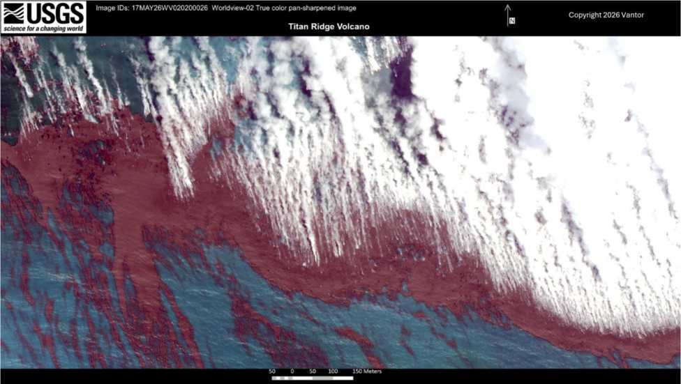
Some large ones on breaking the surface would rapidly decompress and explode, producing small amounts of ash and fragments, the lighter ash components would be carried away in the plume. Note, the depth of the magma source and the local geology for the Tulaman and Titon Ridge eruptions are quite different. Picture supplied by MRA.
Mr Mana said authorities have advised all maritime operators and vessels travelling through the Bismarck Sea region to exercise caution and avoid affected areas where floating pumice deposits have been reported.
“There remains a possibility of tsunami activity as the eruption continues to evolve in behaviour, however no tsunami warning has been issued at this time,” he said.
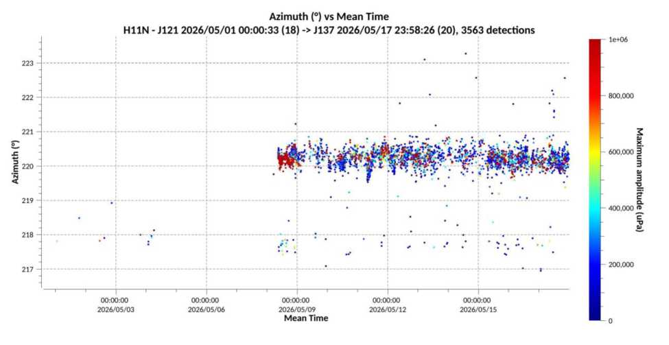
Seismic monitoring over the past week recorded several earthquakes linked to the eruption, including one measuring magnitude 5.4, although volcanic activity has reportedly remained relatively quiet over the past 24 hours.
Mr Mana said the National Disaster Centre would continue working closely with the Mineral Resources Authority, the Geohazards Management Division Volcanological Observatory, the Rabaul Volcanological Observatory and other relevant agencies to ensure continuous monitoring and timely public updates.
People are advised to circulate this situation report in its entirety and are advised to ignore social media posts etc. from third parties. Already there are posts showing images from other places and AI generated content.
Contact: For further information and queries please contact the Assistant Director on contact details listed above. Compiled by: RVO Picture supplied by MRA.
He also urged the public to rely only on official information released by government authorities and disregard misleading social media posts, recycled images and AI-generated content circulating online regarding the eruption.
Further updates are expected as monitoring continues.
Titan Ridge..not Titon
Any historical data on when was the last volcanic activity at Caster Reef and Titan Ridge??